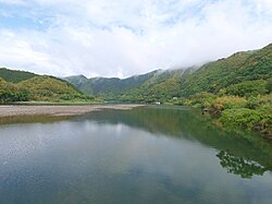
Shimanto River
| Shimanto River | |
|---|---|
 The Shimanto River | |

 | |
| Native name | 四万十川 (Japanese) |
| Location | |
| Country | Japan |
| Physical characteristics | |
| Mouth | |
• location | 32°56′02″N 132°59′45″E / 32.933847°N 132.995722°E |
| Length | 196 km (122 mi) |
The Shimanto River (四万十川, Shimanto-gawa) is a river in western Kōchi Prefecture, Japan.[1] 196 km in length, it has a watershed of 2,270 km2.
Fisheries
[edit]Since the river is remote from major cities and does not have any dams, it is sometimes referred to as "the last clear stream of Japan".[2][3] Fishing and production of nori is a thriving industry along the river.[citation needed]
Lack of dams
[edit]Due to lack of damming of the river, it has been named one of the "Three Free-Flowing Rivers in Japan", along with the Nagara River in Gifu Prefecture and the Kakita River in Shizuoka Prefecture.
Sinking bridges
[edit]The river also has 47 chinkabashi (沈下橋, sinking bridges), including those on its tributaries.[4] Chinkabashi are low-water crossings constructed without parapets in order not to be washed away by floods. The prefecture decided to preserve them as cultural heritage.
See also
[edit]- Yoshino River, which has similar low water crossings
References
[edit]- ^ Nakayama, Keiko (2022-03-02). A Forest Environment Tax Scheme in Japan: Toward Water Source Cultivation. Springer Nature. pp. 120–121. ISBN 978-981-16-9352-6.
- ^ "Shimanto River Headwaters". Tourism SHIKOKU (in Japanese). Retrieved 2025-04-27.
- ^ "Cool Summer Sights / The Government of Japan - JapanGov -". The Government of Japan - JapanGov -. Retrieved 2025-04-27.
- ^ Association, Kochi Visitors & Convention. "Sada Chinkabashi (submersible bridge)". Visit Kochi Japan (in Japanese). Retrieved 2023-10-10.
External links
[edit]
